-40%
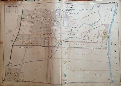
1898 ORIG STATEN ISLAND NY NEW DORP MIDLAND BEACH OCEANVIEW GRANT CITY ATLAS MAP
$ 118.8
- Description
- Size Guide
Description
This is an original 1898 E. Robinson atlas map covering the New Dorp - Midland Beach area of Richmond County / Staten Island in NYC. Measures 22x32. The map is on linen and is in Ex/Ex+ condition.Each color represents the type of structure. Yellow is wood, pink is brick, blue is iron and brown is stone. The X's through the buildings indicate it is a barn or stable. Brown indicates stone structures.
I am selling my collection of rare maps. If there is an area or street address of
Long Island, Westchester, Brooklyn, Manhattan, Queens, Staten Island, Bronx, Elmira, Buffalo, Rochester, Troy, Newark, Atlantic City, Essex, Berks, Montgomery, Bergen, Counties, Baltimore, New Orleans, Portland, Maine, Seattle, Cleveland, Baltimore, Toronto, Montreal, Vancouver, Denver, Portland, Maine, Philadelphia, Rochester, Toledo, Pittsburgh, Harrisburg, Wilkes-Barre, Reading, Bucks, Delaware County, Boston, South Boston, Dorchester, Roxbury, Brighton, Worcester, Brookline, Haverhill, Malden, Middlesex County, Lawrence, Quincy, Salem, Massachusetts and other cities
that you might be interested in, contact me. I have insurance maps from 1880 to mid-1950s. Looks great framed!
Check out my
other items
!
NOTE: Key in last photograph does not appear in actual map. It is just a reference to indicate what each symbol and color stands for.


