-40%
Des Arc Missouri Vintage 1929 USGS Topo Map Annapolis 15-minute Topographic
$ 27.45
- Description
- Size Guide
Description
DES ARC MISSOURI 1929 USGS TOPOGRAPHIC MAPVintage Cartographics
Missouri Maps
∙
Antique Prints
∙
Bargain Bin
∙
Browse Nearby Sheets
1929
Des Arc
Missouri
USGS TOPOGRAPHIC MAP
first-year print in excellent condition
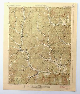
For sale is the 1929 edition of the Des Arc 15-minute map. This map would be ideal for framing or display, historical reference or research, genealogy studies, adding to your collection, treasure hunting, a nice conversation piece, a gift for a history or map enthusiast, or for anyone interested in this area.
This sheet includes the only survey produced by the United States Geological Survey for the Des Arc 15-minute quadrangle. The map sheet is an original 1929 USGS print in excellent condition.
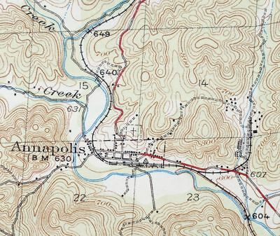
The Des Arc 15-minute map shows all roads, paths, towns, railroads, rivers, creeks, elevation contour lines, public land survey lines, county, state, and other administrative boundaries as they existed at the time of the survey in 1926. All known structures (houses, businesses, churches, schools, barns, cabins, etc) are also shown, with exceptions in some urban areas, where only landmark buildings may be shown.
The Des Arc map was field surveyed before aerial photography methods were widely used in map data gathering. It was drawn by cartographers based on plane table field survey information as well as information gathered from local residents in the area. It displays the remarkable abilities of early government map makers, who placed a strong emphasis on creating complete, accurate, and cartographically appealing maps.
Maps from the 15-minute series for the continental United States are no longer produced or printed by the USGS and original prints are becoming increasingly difficult to find. They are a valuable historical record for an area, as they contain many placenames and features that have been dropped from more recent maps.
MAP DETAILS
Title
Des Arc
State
Missouri
Series
15-minute
Surveyed
1926 Field Survey
Geographer
Frank W. Hughes
Edition
1929
Printed
1929, thick paper stock
Woodland Tint
Yes
Scale
1:62500
Contour Interval
20 Foot
Sheet Dimensions
16 1/2 x 20 inches (approximate)
Map Dimensions
13 7/8 x 17 1/2 inches
Coverage Area
14 x 17 miles
SHEET CONDITION
For maps of this vintage, effort is made to note all visible flaws, no matter how minor.
Overall Condition
EXCELLENT
Sheet Notes
very lightly handled, never folded
Map Area
flawless map area
Collar Area
no markings, very minor blemishes, no edge tears, minor handling wear on top collar, small inventory stamp in upper right collar corner
MAP COVERAGE
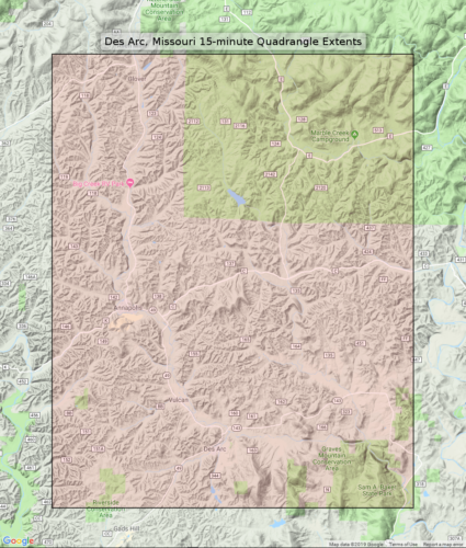
Quadrangle extent overlaid on current basemap.
Browse Nearby
Sheets
PLACENAMES
Depending on map series and survey date, all of the features listed below may not be shown on this map. This list contains features that currently exist or historically existed within the area covered by this map. The list can be used as a reference to determine if this map covers your area of interest. Placenames are listed alphabetically next to each feature type.
Cities and Towns
(current)
Annapolis, Des Arc, Glover, and Sabula
Counties Covered
Iron, Madison, Reynolds, and Wayne
Federal Land Units
Mark Twain National Forest
Rivers and Streams
Bear Branch, Big Creek, Black Creek, Brushy Creek, Camp Creek, Carver Creek, Crane Pond Creek, Funk Branch, Glade Creek, Goose Creek, Island Branch, Leatherwood Creek, Little Carver Creek, Little Creek, Little Rock Creek, Logan Creek, Lower Rock Creek, Marble Creek, Marsh Creek, McKenzie Creek, Mill Creek, Patterson Branch, Patterson Creek, Richland Creek, and Sulphur Creek
Water Bodies
Asarco Lake, Collins Lake, Crane Lake, Shy Lake, and Walnut Hollow Lake
Populated Places
: Chloride, Annapolis, Berryman, Beulah, Brunot, Des Arc, Glover, Jewett, Minimum, Sabula, and Vulcan.
Locations
: Crane Lake Picnic Area, Leadanna, and Marble Creek Campground.
Administrative Boundaries
: Township of Arcadia, Township of Liberty, Township of Liberty, and Township of Union.
Mountains, Peaks, and Summits
: Crowley Hill, Des Arc Mountain, Grassy Mountain, Graves Mountain, Green Mountain, Hickman Mountain, Lewis Mountain, Mudlick Mountain, Patterson Mountain, Rocky Mountain, Ruble Mountain, and Stony Mountain.
Valleys and Canyons
: Brushy Hollow, Cedar Spring Hollow, Cunningham Hollow, Des Acre Hollow, Dry Hollow, Henderson Hollow, Mash Hollow, McCue Hollow, Mudlick Hollow, Reader Hollow, Slabtown Valley, Sutton Hollow, Tilk Hollow, and White Hollow.
Parks
: Sam A Baker State Park.
Drainages
: Black Creek, Brunot Creek, Brushy Creek, Carver Creek, Crane Pond Creek, Glade Creek, Goff Branch, Goose Creek, Island Branch, Kinney Branch, Little Carver Creek, Little Creek, Mill Creek, Patterson Branch, Patterson Creek, Richland Creek, and Sulphur Creek.
Mines
: Annapolis Lead Mines, Dinger Iron Bank, E W Graves Porphyry Quarry, J.S. Benson Porphyry Quarry, Lindsey Iron Bank, Russell Number Two Iron Bank, and Singer Iron Bank.
Churches
: Big Creek Church, Black Mountain Church, Beulah Church, Free United Church, Full Gospel Church, Liberty United Church, and New Peace and Harmony Church.
Forests
: Graves Mountain State Forest.
Lakes and Ponds
: Blue Hole, Section House Hole, and Slab Pond.
Dams
: Crane Lake Dam, Asarco Lake Dam, Asarco Section 11 Lower Dam, Asarco Section 11 Upper Dam, Chain of Lakes Dam Number 1, Chain of Lakes Dam Number 2, Chain of Lakes Dam Number 3, Lawless Lake Dam, Number 466 Dam, Number 654 Dam, Number 809 Dam, Schultz Lake Dam, Shy Lake Dam, Walnut Hollow Lake Dam, and Walnut Hollow Lake Section 2 Dam.
Other Features
: Shut-Ins.
Reservoirs and Tanks
: Crane Lake, Asarco Lake, Chain of Lakes, Shy Dam, Shy Lake, Shy Lake 2, and Walnut Hollow Lake.
Towers
: Crane Lookout Tower and Vulcan Lookout Tower.
Trails
: Crane Lake Trail.
Springs
: Blue Spring, Tank Spring, Webb Spring, and Weeping Willow Spring.
Schools
: Black Mountain School, Blue School, Bollinger School, Brunot School, Collins School, Funk School, Glover School, Jewett School, King School, and Roberts School.
BACKSIDE LEGEND
A map summary is printed on the back side of the Des Arc sheet similar to the one shown in the picture. It outlines the history, purpose, and status of the USGS mapping program at the time of the printing in 1929. It also provides instructions on how to read contour lines and a description of how they are used to depict the terrain. At the bottom of the page is a legend showing all of the symbols used to represent the cultural, relief, and water features found on the map.
SHIPPING AND RETURNS
This map sheet will be carefully rolled in a sturdy tube and shipped via the US Postal Service. Shipping and handling costs are included in the purchase price.
If you find that the sheet you receive is not as described in the listing, you may ship it back to us for a refund of the purchase price.
15~8527 15~8528 15~8529 15~8530 15~8531 15~8720 15~8721 15~8722 15~8723 15~8724 15~8725 15~8726 15~8911 15~8912 15~8913 15~8914 15~8915 15~8916 15~8917 15~9101 15~9102 15~9103 15~9104 15~9105 15~9106 15~9107 15~9290 15~9291 15~9292 15~9293 15~9294 75~33029 75~33030 75~33031 75~33032 75~33408 75~33409 75~33410 75~33411 75~33412 75~33413 75~33785 75~33786 75~33787 75~33788 75~33789 75~33790 75~33791 75~33792 75~34158 75~34159 75~34160 75~34161 75~34162 75~34163 75~34164 75~34165 75~34531 75~34532 75~34533 75~34534 75~34535 75~34536 75~34905 75~34906 75~34907 75~34908


